Sunday, December 22, 2013

8th Annual Ten Thousand Islands Canoe Trip

This past week, the usual suspects geared up to head out to the Ten Thousand Islands again.  Luckily, my husband was able to get the time off work to join us this year for his second time.  We wanted to further explore some of the northern islands so we chose to again leave from Port of the Islands.  However, to avoid the boat ramp fee, we left from a park just on the north side of the road on the water.  


Phil, Alec, and I at the launch site


We brought 2 of our own kayaks and rented 2 canoes from Everglades Adventures through the Ivey House.  They were by far the best place we have rented from any year.  They were on time (even though we weren't), flexible, and had great pricing even for non-hotel guests.  We got started about an hour later than intended which made us nervous since we didn't want to end up fighting the tide.  We still had plenty of time to make it out of the long, boring channel though before the tide changed and even saw some wildlife.  


Roseate Spoonbills

White Pelican

We weren't 100% sure of where we wanted to camp yet but knew it was between the north side of Panther Key, Hog Key, or Whitehorse Key.  We stopped for a quick lunch on the south side of Panther Key then headed around the gulf side, passing some feeding Bull Sharks,to head to Hog Key. While Hog Key looked beautiful from far away, it was definitely lacking in camping options.  Over the years we have become somewhat of campsite snobs and now only the prettiest will do.  We jumped back in the canoes and decided to head back to Panther Key.  We chose the spot right near the lagoon entrance.  


Our campsite at sunset

The next morning we decided that we would keep our campsite for the next 2 nights and just do day trips to explore the other keys in the area.  We first headed back over the Hog Key to check out a beautiful cove Eric told us about.

Path to cove on Hog Key

Cove on Hog Key at low tide

Next we headed over to Whitehorse Key since we had seen many beaches on it on Google Earth.  Whitehorse Key ended up being gorgeous with many beautiful beaches to camp on.  We ran into a couple of guys from Tennessee who said the rest of the group was on the other side of the island but we didn't hike all the way around.  

Exploring Whitehorse Key


Next, I wanted to go check out Dismal Key, where a hermit used to live.  We still haven't learned our lesson and yet again did not have a GPS, but it looked easy enough to find on the map.  Unfortunately, somewhere we took a wrong turn and ended up in some lagoon.  We were able to backtrack and get back to our campsite but I was super disappointed.

That evening while we were cooking dinner, my husband set up a fishing line baited to catch Bull Sharks.  Sure enough, within 30 minutes we heard the whirl of the reel and we hooked a bull shark.  Everyone took turns reeling it in so we could get pictures before releasing it.


The next day we decided again to attempt to find Dismal Key.  This time, Eric gave us good directions since he is expert navigator, and we found it without any problems.  I had read the autobiography written by Al Seely (one of the former hermits of Dismal Key) and had been wanting to visit it for awhile.  I had studied on Google Earth where the house and other buildings had been located and by following the tree line was able to find it!  Other than the cistern, there's not much left in terms of buildings.  We found the ruins on an old dock, the cornerstones of where the 1935 cabin used to be, and possibly the remains of an outhouse.  We did find tons of old bottles, cans, and other home furnishings such as pieces of rugs, the old icebox, and a bed frame.  I'm not sure which hermit it was since there were 2 in the later years but someone really liked Busch Beer since we found hundreds of beer cans out there.  It's a great lesson in recycling.

Dock remains

Cistern

Pile of old trash where center of house was

Cornerstone of house?

What's this? (We believe it was an ice cube tray from fridge)

Outhouse ruins?

Playing archaeologist on Dismal Key 

Different plant life than on other keys

We were also interested in the very different plant life on Dismal as opposed to other keys.  Dismal Key is almost entirely made up of an old Native American shell mound which makes it much taller than other keys.  It also contains a huge variety of plants such as Gumbo Limbo trees, wild poinsettia, and many types of cactus. After exploring Dismal Key, we ate some lunch on the oyster shell beach.  On our paddle back to Panther Key, we had to fight some strong winds, which made us feel as if we earned our beer when we got back to camp.

Relaxing in the water after returning to camp

That evening we caught another Bull Shark while prepping dinner.  Eric also caught some Redfish so we grilled those up for the omnivores.  For some reason, we were surrounded by bees while cooking dinner.  They weren't threatening in anyway but just annoying.  So we created a bee feeder out of a lid filled with Mountain Dew and that kept them focused on that and not us.


The next morning we had planned on paddling all the way back to Everglades City but Eric's weather radio was warning us of headwinds up to 19 knots.  We decided our best bet was to wake up incredibly early since the wind usually picks up in the afternoon.  We woke up at 6AM and launched by 8AM, but when we rounded the point of Panther Key we were smacked with strong winds.  We quickly came up with a plan B of going back to Port of the Islands and calling Everglades Adventures and having them pick us up there.  Unfortunately, with this decision we were fighting the tide the whole way back.  However, it was still the better option since those winds would have slowed us down tremendously and tired us out.  

It was, again, a great trip with good people and good food.  That's all you need!

Heading home


Sunday, November 10, 2013

12-Mile Fisheating Creek Hike

Yesterday I met a group of 9 other awesome hikers at the Fisheating Creek Outpost in Palmdale, FL.  Our group leader is somewhat known for just finding or creating his own trails.  He had used Google Earth previously to find his own way of hiking from Ingrams Crossing back to the Outpost.  We had the shuttle driver drop us off at the canoe put-in, forded the now shallow creek (due to it being dry season) and began our hike back to the outpost.


 We basically followed the fence-line along the Lykes Bros. property.  Sometimes we would walk along the fence and sometimes in the dry cypress floodplain.


The morning started off slowly since we kept running into wildlife we wanted to look at.  We saw many wild hogs since that area is overrun with them, we saw a couple of deer, lots of birds, a pygmy rattlesnake, and some baby gators!


On our lunch break we realized that we had only walked 4 of the 12 miles and were making not such great time.  So in the afternoon we had to pick up our pace with fewer breaks and photography opportunities.  After around 6 miles, we had to turn back into the forest and cross the creek again to follow another fence-line.  At this crossing we could see an old hunt camp.


After 9 miles we came across some wild orange and grapefruit trees and just had to stop for a snack.


At this point we were all more tired than on a normal hike since we weren't exactly hiking on a trail.  We were having to pick our way through waist-high grass (while avoiding snakes) and stepping over cypress knees which wears you out pretty quickly!  We continued hiking for another 3 miles or so until we finally got back to the outpost right at sunset.  We finished the evening off with some drinks and food at the Clewiston Tiki Bar then headed home.


Sunday, September 15, 2013

Loxahatchee River Day Paddling Trip

Yesterday, my dad and I joined a group of friends for a day trip down the Loxahatchee River.  We met up in Riverbend Park in Jupiter, FL and rented our canoes from the Canoe Outfitters in the park.  We stopped under the first bridge to look for bats and found a few.


Because it's still the rainy season the water levels were very high.  The first section of the river was by far the prettiest.  It was open but not too wide.  It was lined with tall cypress trees and beautiful undergrowth.


Eventually it became narrower and curvier as it wound through the cypress and palm trees.  Luckily my dad is an expert paddler and navigated us without any real problems.


We stopped at a large downed tree, parked our canoes and most of us ended up swimming for awhile.  It was fun to try and swim against the strong current.  Shortly after this stop we arrived at the first dam on the river.  Because the water was so high it was barely noticeable as we paddled over it.  A short distance later we arrived at the second dam (also known as Masten dam).  When the river is lower, it can sometimes create a problem for paddlers.  There is a ramp to get your boat over it if you do not want to paddle over it. Again, due to high water, it wasn't a problem.  Soon, the noise from the Turnpike and I-95 bridges became louder and we eventually paddled underneath them.  Most paddlers choose this point to turn again and head back to the outfitters.  The outfitters are responsible for maintaining the river up this point and the state park service and responsible for everything further downstream.  Unfortunately, they prefer to let the river in this area between I-95 and Trapper Nelson's place remain in its natural state so it can be very challenging to paddle through.

This section of the river took the longest since we encounter many obstacles such as large fallen trees blocking the river, low hanging branches, spider webs, and confusing river forks.  We attempted to look for the Governer's Dock but never did see it.  We assumed the water might have been too high.  Finally, we reached Trapper Nelson's place in Jonathan Dickinson State Park.  


Here we sat at the picnic tables to eat our lunch while listening to stories from the park rangers.  They were certainly a wealth of knowledge about Trapper Nelson and his life in this area.  My favorite part was hearing the stories about Trapper's family members that had visited the park since his death in 1968 and had provided them with even more stories and artifacts.  After we ate, we walked around the compound to look at his cabins, "zoo", smoke house, and even a modern bathroom.  While Trapper Nelson lived here, he not only hunted and sold furs to live off the land, he also created a zoo and tourist attraction.  


Finally it was time to head back and meet our shuttles.  Downstream from Trapper Nelson's place the river becomes much wider.  We even ran into some motor boats and jetskis.  We also saw 4 manatees!


We stopped for a quick swim at the "beach" at Jonathan Dickinson before paddling the 1/3-1/2 mile back to the boat ramp.  The trip in total was somewhere around 10 miles and took us around 6 hours with all of our stops.  Definitely a fun but challenging trip!

Tuesday, September 10, 2013

Florida Trail: Jonathan Dickinson State Park East Loop

This past Saturday my dad and I headed up to Jonathan Dickinson State Park in Hobe Sound, FL to hike the East Loop trail.  According to my guidebook it was listed at 9.8 miles.  We knew the weather was going to be hot so we arrived right when the park opened at 8 AM.  We started our hike by 8:15.  The first couple of miles are a bit challenging since you are walking on sugar sand.  Within the first 3 miles we started questioning the accuracy of my book's hike description.  According to the amount of time we had hiked, we should have gone farther than the books' description.  We assumed we were just making poor time due to the sand and kept going.  Eventually we reached a trail marker that proved we had gone a mile further than we had according to the book.  We headed towards the Scrub Jay campsite.  Because the entire park had undergone a prescribed burn about 7 months prior, most of the undergrowth was gone and there was almost no tree cover or shade.  This coupled with the sun's reflection off the sand made for a very hot hike.  We reached the Scrub Jay campsite, which consists of two large backpacking sites each with a picnic table and fire ring.  Here we stopped for lunch and discussed potentially camping here in the cooler months.  On our way out we passed a working water pump and a very fancy and clean solar powered privy.  Definitely a luxurious backpacking site!  At this point the trail split and you could continue on towards the Kitching campsite or head back to the parking lot.  We headed back to the front of the park.  While we had to cross over a lot of water obstacles, almost all of them had semi-hidden bridges off to the side.  Finally, we reached an ankle deep creek with no bridge.  We stopped to remove our shoes before crossing since the thought of hiking another 4+ miles in wet boots was unappealing.  The later part of our hike was much more challenging due to the 90 degree weather and lack of shade.  At one point, the trail joined up with a biking path and we didn't see any blazes for awhile.  Just when we were considering the idea that we had missed the turnoff, we saw a blaze ahead.  Just towards the end, the trail makes a sharp turn and detours you to walk along a really pretty lake.  We were definitely happy to reach the car!  Overall, this was a challenging hike due to the never ending sugar sand and high temperatures.  We will consider doing it again in the winter as an overnight trip.  Also, if you read a description about this trail and it is listed at 9.8 miles, this is incorrect!  It is actually 10.8 miles.  While the 1 mile difference is not that big of a deal, it created confusion during the first part of the trip.

Friday, August 30, 2013

Gear Review: REI Flash 52 Backpack Women's

I ordered the REI Flash 52 Backpack for our recent trip to hike about 60 miles of the Appalachian Trail since mine was getting old and there were so many newer, lighter packs out there.  I read a lot of reviews for different women's packs and decided to go ahead and order this one.  Because there are no decent stores that carry hiking equipment in South Florida, I went ahead and ordered it from rei.com.  I checked their measurement guide and found that I fell right in between the medium and large sizes.  Since the large offered more cubic inches, I went ahead and ordered that one.

It arrived pretty quickly in the mail and I was excited to open it.  I loved the number of pockets as well as their placement.  It's a pretty light pack at around 3 lbs.  I was also able to use the rain cover from my old REI backpack so that saved me from having to pay for another one.  I then made the mistake of not testing it out before hitting the trail.  When I reached GA, I ripped the tags off the new backpack before filling it with my gear.  On the first day of my hike when the shuttle driver dropped us off he commented on how my backpack looked way too big for me.  Uhoh.  At this point I was committed and didn't have a choice.  The first day of hiking with it was fine but after that my back started hurting a lot from the straps not being properly positioned since the pack was just too tall for my torso.

Other than the size I still loved everything else about the pack.  On our drive back to Gainesville, FL we decided to stop at the REI in Atlanta.  Can I just say that REI has an amazing return policy?!  They took back my wet, muddy, used backpack and gave me a brand new one in size medium with no questions asked!  One of the employees even took the time to load it up with some weight so I could walk around the store with it to make sure that the medium was the correct size.  When I returned it the backpack was also on sale so they gave me a credit for that which I used to buy a new orange mesh camping chair.  So now I have another new backpack, a mesh chair, and REI will continue to get my business!

Wednesday, August 28, 2013

Appalachian Trail: Hogpen Gap, GA to Deep Gap, NC

Warning:  This is a very long post because it includes 5 days of hiking on the Appalachian Trail.  I also apologize for the lack of photos in the post.  The camera I brought was old and the battery died within a day.  Most of the pictures in the post were borrowed from the internet.  I take no credit for them.

The next morning after our Blood Mountain hike, Auz and I got up fairly early to pack up the car, eat some breakfast then meet Lumpy at our terminus which was the end of Deep Gap Rd in NC.  Prior to our trip I had tried to find this area on Google Earth because I suspected that there wouldn't be much in terms of cell phone reception in that area.  I was correct.  Luckily, I had mapped out exactly which turns to take down the almost 15 miles of dirt road we had to drive.  Because it was still dark out it was a little spooky going down Deep Gap Rd with no cell phone reception in case something went wrong.  We found Lumpy at the bottom of the gap with no problem!  After moving our stuff to his van, we locked our car, and started the drive back to Hogpen Gap, GA.  The drive took about 1.5 hours and on the way he told us stories about how he was frequently mistaken for one of the members of Duck Dynasty (there was an uncanny resemblance).

He dropped us off at the Hogpen Gap trailhead and told us to text him when we emerged from the trail a few days later.  It was lightly raining so we started off with our rain gear on.  As usual, within a mile we were too hot from the impenetrable jackets and took them off.  The first 4 of 11.5 miles were fairly flat and felt really easy compared to the Blood Mountain hike the day before.  We stopped for a snack of almond butter on pita bread at Low Gap Shelter.  We were not planning on staying here overnight but it was really a beautiful area.  There was a small creek that ran right through camp.  There was a note on the shelter wall warning of a Cottonmouth snake in the privy.  We went up the side trail to check it out.  Because Auz is a Herpetologist by hobby she found the snake but confirmed it was not a Cottonmouth but merely a brown water snake so we edited the prior warning note.  Just before leaving the shelter 2 women came down to use the privy and we told them about the snake.  They were actually running 30 miles of the trail that day and we would probably see them later.

The next 4 miles followed a gentle uphill and were also fairly easy on us considering the weather.  We then reached a short steep descent followed by 3 more miles of ascent before reaching the Blue Mountain Shelter.  Right as we were about to get to the turnoff, the skies opened up and it started pouring.  At this point we started a near jog on the trail but were confused by the signs.  We knew the shelter trail was supposed to be on the left, yet there was a sign pointing us straight ahead.  After going straight, we realized we had probably passed it and turned around.  Back at the sign we turned down that trail and found the shelter.  We changed into dry clothes and decided to just set up our tent sans rainfly inside the shelter since no one was there and it was nearly 5 PM. We made a delicious dinner of Tasty Bites Indian food followed by some maple cookies we had picked up at Trader Joe's that lacked any real maple flavor.

Blue Mountain Shelter (not my picture)

Around 8 PM we were just relaxing in the shelter listening to the rain when we heard voices approaching.  Soon, 2 guys appeared at the shelter and told us that 2 more of their buddies were on their way.  They were young guys from New Orleans and Phoenix.  We watched as they began unloading their massive backpacks.  They pulled out what looked like a 40 lb Coleman tent, a large metal pot, cases of ramen noodles and packets of tuna fish.  They divvied up the chores of filtering water, setting up the tent, and starting a fire.  The thought of even attempting a fire hadn't occurred to us since it had been raining for days and all the wood was soaked through.  We watched as they used a machete to attempt to chop firewood and get that going.  We were a bit confused as to why they were so determined to get a fire going until we realized that they hadn't packed a stove and needed to fire in order to make their dinner.  What a mess.  They were so unprepared!  We fell asleep shortly after but I don't think they went to bed until midnight.

Our watch alarms were set to go off at 6 AM the next morning but upon awakening, we realized it was still raining and decided to wait another hour.  A few minutes later one of the guys stumbled into the shelter with his sleeping bag and asked if he could sleep in there since their tent had flooded.  Big surprise...that's what cheap tents do.  He said they were also planning on hiking to Tray Mountain Shelter that night.  We said we would see them later and started packing up our gear and making breakfast.  We wanted to get an early started since we knew today's hike would be challenging.  There was the steep 1 mile descent into Unicoi Gap, followed by the 1+ mile steep ascent up Rocky Mountain.  Then there was the Other steep descent to Indian Grave Gap, an ascent to the "Cheese Factory" campsite (named after an old dairy farm that used to be in the area), and on last climb over Tray Mountain.  While it was only going to be a 7.5 mile day, it was all diagonal.  It also rained all day which added to the fun.  We stopped for a short wet break at Indian Grave Gap which we had been to years before when we hiked up the Andrews Cove Trail from SR 75 outside Helen.  Here we had a quick lunch of red pepper hummus and crackers.  Parts of this section of the trail were very rocky and precarious when wet.

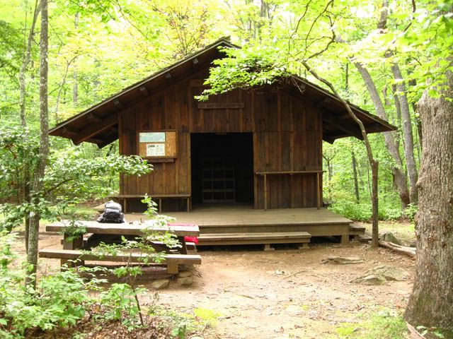
Because there were few stops, we reached the shelter pretty quickly and before 3 PM.  After setting up our tent, we went to find water.  Unfortunately for our tired legs, it was a long descent down a steep hill to get to the water source.  After trudging back up the mountain, we decided we had the time for a quick rinse in the creek.  We grabbed a change of clothes and our pack towels and headed back down to the water source to rinse off.  The skies finally cleared up a bit and we relaxed in the shelter and watched 2 salamanders on a log.  A bit later, a couple and their two dogs joined us in the shelter.  They said hello but not much else to us that day.  The 4 guys from the previous night never did make it.  We assumed they hitched a ride back to Helen at Unicoi Gap.  For dinner we made gluten-free pasta (we wanted to test this out since it cooks in half the time as wheat pasta with a very similar texture) and rehydrated some olive and tomato sauce.  It was delicious on a rainy night.

Tray Mountain Shelter (not my picture)

Attempting to dry our clothes at Tray Mountain Shelter in the rain
(my picture)


The next morning, our spirits were lifted as we saw hints of blue in the sky.  This was the first blue sky we had seen since arriving in Georgia!  We happily made breakfast, fetched more water, and packed up our gear only to get rained on within 1/2 mile of hiking!  Downtrodden, we continued our descent to Wolfpen Gap.  Today our plan was to go 7.5 miles to Deep Gap Shelter.  The beginning part of our hike was slightly hilly but nothing too crazy.  After Sassafras Gap we had a steep descent to Addis Gap followed by a long, difficult climb over Kelly Knob then the final descent to Deep Gap.  Maybe it was because we had been hiking for a few days but I would put the difficulty of Kelly Knob up there with Blood Mountain.  It was hard!

Deep Gap Shelter was an actual enclosed 2-story cabin type shelter.  The privy also had a roof on it (the previous ones hadn't and were disgustingly slimy) so we were living in style now!  We got there really early at around 1 PM and because EVERYTHING was wet from so many days of rain, we hung up our gear all over the shelter.  We hadn't stopped for lunch so we ate our pita bread and Justin's Maple Almond butter.  Because the roof on the shelter had recently been replaced the ground around it was littered with nails.  We picked up as many as we could because it would really suck to get one of those rusty things stuck in your foot.

A couple of hours later a flip-flopping thru-hiker named Dragon Stick joined us.  We moved our drying gear to make a spot for him in the shelter.  Because of the relentless rain, we sat on the front porch and he told us about his hike and his gear.  He lived near DC so he had started in Shenandoah and hiked north to Katahdin in Maine.  There he got on a plane and headed to Atlanta to hike from Springer back to Shenandoah.  His trail name was from his hiking stick that he had carved in the shape of a dragon complete with sharks teeth in its mouth.  While he was retired, he was still on the board of some organization and carried with him 8 cell phone batteries so that he was always reachable.  His wife was also able to call him daily on the trail.  It was so strange to hear text message noises out here!  For dinner I made a cous cous pilaf with rehydrated vegetable and spices and cookies for dessert.

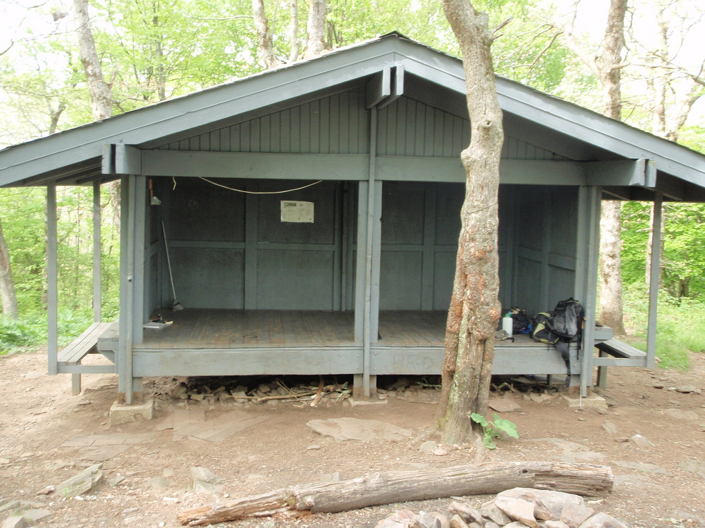
Deep Gap Shelter (not my picture)

The next morning we had a leisurely breakfast then headed out.  Dragon Stick said he would see us that evening at Plumorchard Gap shelter but he was staying here until noon to take a conference call since he had good reception.  We had an 8 mile day ahead of us with some pretty challenging climbs.  The first challenge was a steep 1 mile descent from Powell Mountain into Moreland Gap followed by a further descent to Dicks Creek Gap.  Overall the first 4 miles of the day were pretty quick.  From the road crossing we had the 1+ mile steep climb up Buzzard Knob, a short dip into Bull Gap, then the final descent towards Plumorchard Gap which seemed to go on forever!  While the map claims that it is only 0.2 mi off the main trail, it was by far the longest 0.2 mi of the day.  We crossed over the creek and water source and finally arrived at the beautiful shelter.  This shelter was a 3 story one with lots of hooks for hanging things.  Had it not been so overcast, this would have been the prettiest one yet (minus the loads of trash in the fire pit, c'mon, a tire???)

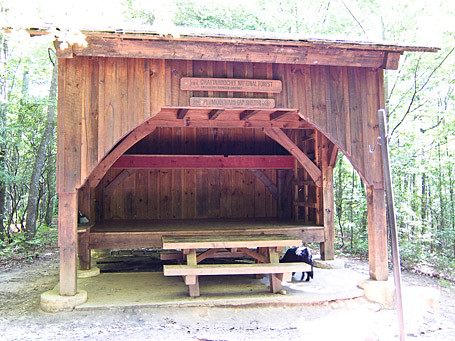
Plumorchard Gap Shelter (not my picture)

Path to the Privy (Auz's picture)

It was still raining so we decided to put out our bowls to collect water in that we could filter later to save ourselves a trip to the creek.  We checked out the privy which was also fancy, covered and lacked snakes.  We put on the driest clothes we had which were still pretty soggy and ran some line to attempt to dry our belongings in 95% humidity.  I had been sleeping in a damp but warm sleeping back for so many nights, what was one more?

Our clothesline at Plumorchard Shelter at night
(This is our picture which is why it sucks)

Dragon Stick arrived at the shelter a few hours after we did.  He said he ran into a father and daughter who claimed they were heading to the shelter for the night but they never did make it.  Probably gave up due to the rain and turned back to the car.  For dinner we ate our last packets of Tasty Bites Indian food and gorged ourselves on snacks and cookies, leaving just enough for the next day's lunch.  We hung the remainder of our food on the bear cables and went to bed early.  We had a 12 mile day in the morning so we set our watch alarms for 5 AM.  Dragon Stick also wanted to wake up at that time since he had an 18 mile day ahead of him.  That night we heard coyotes a few times as well, which was awesome.  In the morning, Dragon Stick yelled that a small rodent had gotten into our food.  Upon investigating, his bag had been torn open and he was missing some granola bars but our just had a small tear.  We shoved our soaking wet clothes and gear into our packs, ate our Banana Walnut Chia Seed Oatmeal and got more water.

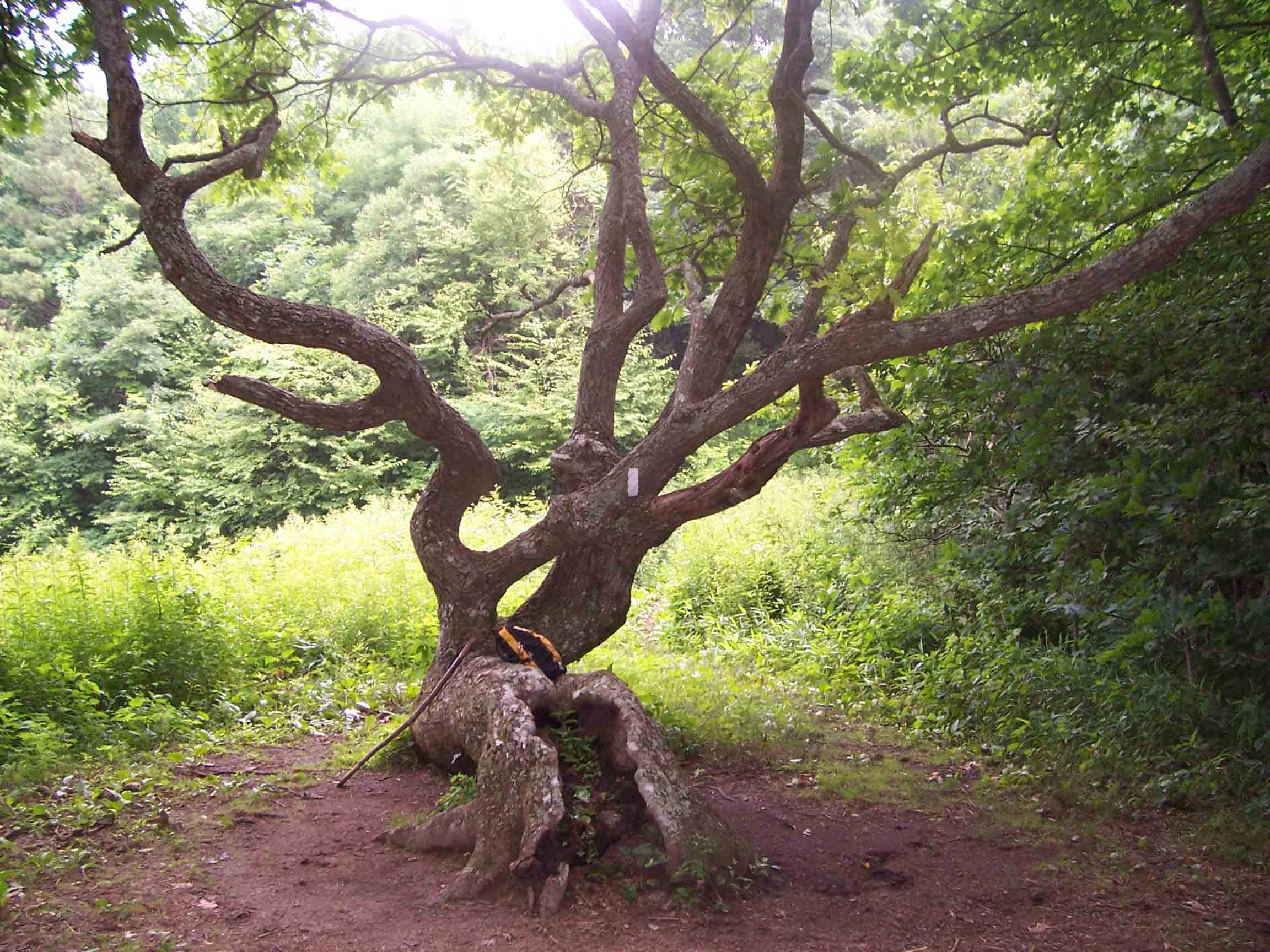
There was a small climb over As Knob in the morning followed by a gentle climb for a couple miles to the GA-NC border.  The rain had finally let up!  It was such a pleasure to not be hiking in a downpour for once!  The first 5 miles to to the border went by really quickly.  After crossing the border, there is a short climb up to Bly Gap where there is an awesome tree and a beautiful meadow of flowers.

Bly Gap Tree
(not my picture)

From here, we had a incredibly steep climb up Sharp Top.  The unnamed peak you climb over right after was equally as sheer of a climb.  From this point on the trail looks very different from Georgia.  We entered a rhododendron tunnel followed by a foggy pine forest and lots of wild flowers.  After about 8 miles, Auz became exhausted with only 4 miles to go.  Her feet were also in pretty bad shape from being wet in too small boots for too many days.  Meanwhile, my back was hurting more than my feet from having a too large backpack (see backpack review).  I talked her through the last part of our hike by telling her summaries of pretty much every movie I had seen in the past 3 years.  The last mile of the day/trip was the longest and hardest.  It was downhill and slick rocks on tired legs.  When we FINALLY reached the card, Auz removed her boots and promptly threw them in the nearby trashcan, wishing to never touch them again.  We put on our flip flops, threw our wet bags on towels in the backseat, and headed back up Deep Gap Rd to the highway.  

Our plan was to drive back to Helen and stay at the Heidi Motel for the evening to relax and regroup before our long drive home in the morning.  We checked into our room, which was quick spacious and clean, showered, then headed into town to eat at La Cabana for the third time on this trip.  After lunch/dinner, we went to the park next to our hotel and sat on the bench swing for awhile.  We then went down the hill to the small grocery store, bought some sodas, went back to the room and watched TV until we fell asleep.

Heidi Motel
(not my picture)

In the morning we packed up the car and headed towards Atlanta to return my backpack at REI.  Afterwards, we had a long drive back to Gainesville, FL.  On the way, we decided we were sick of the car and took a small detour to go to Horse Creek Winery in Nashville, GA.  Conveniently, it was Happy Hour so the wine tastings were 1/2 off.  After tasting a few wines and being very unimpressed, we sat on their beautiful front porch for a bit before heading back to the car.

Wine on the front porch of Horse Creek Winery

Overall, we hiked almost 50 miles in 5 days.  It was a very difficult, wet, but fun trip.  Our feet are still recovering and yet we are already discussing plans for our next hike.